 My friend Miriam is training to climb Cerro Aconcagua in the Central Andes in Argentina. It’s one of the Seven Summits and the highest mountain in both the Western and Southern Hemispheres. As part of her training, she goes on long and grueling hikes around Bay Area peaks and this weekend she invited me and my friend Laurie to come along.
Early Saturday morning we drove up to Stinson Beach, where the Mount Tamalpais hiking loop begins. The fog was thick when we started at the base of the Dipsea Trail. The cool and damp air was perfect for our ascent up the hillside.
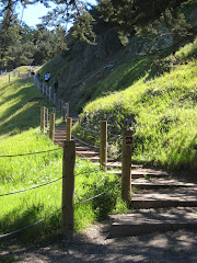
Most of the 7.3 mile trail was shaded by Douglas firs and California bays. Along the way we saw waterfalls, a variety of ferns and countless other plants. The sound of the water flowing down the creeks was soothing. Everything was so green and full of life. I felt a burst of energy every time I took a breath. There was something almost spiritual about it.
The path eventually crossed over to the Steep Ravine Trail and then to the Matt Davis Trail. The last trail took us up through a sunny grassy hillside with spectacular views! You could see all the way to San Francisco’s Twin Peaks. The fog at the base of the hillside had not burned off yet and looked like a giant puffy white blanket covering the coast side. It was like hiking above the clouds. Our descent took us through some tight switchbacks and more gorgeous forestry.
We finished our amazing journey in 3 hours and then enjoyed a nice lunch in Stinson Beach. This hiking loop is now one of my favorites in the Bay Area and I’ll definitely be back soon!


No comments:
Post a Comment